
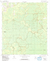
1958 Map of Madison SW
USGS Topo · Published 1959About this map
San Pedro Bay dominates this late-1950s landscape, illustrating a vast wetland wilderness characterized by complex drainage patterns and dense swamp vegetation. The terrain is marked by its low elevation and significant hydrologic features, with a network of unnamed streams and cypress strands that historically defined this part of Florida. Human encroachment into this environment was minimal during this period, centered primarily around the New Oakland Ch in the northwestern corner of the quadrangle. The map highlights the intersection of the Madison County and Taylor County line, which bisects the wetlands. Observation and management of this remote area are indicated by the presence of the Sinclair Lookout, a critical point for monitoring the timberlands and swamp during the mid-century era.
Find a feature on this map
6 named features on this map. Tap any name to fly to it.
Don’t see what you’re looking for? This feature index may not catch every label — zoom into the map to look around manually.
Map Details
Editions of this 1958 Madison SW Map
2 editions found
Other maps of this area

1954 · Day
USGS Topo · 1:24,000

1954 · Boyd
USGS Topo · 1:24,000

1954 · Day NW
USGS Topo · 1:24,000

1954 · Greenville NE
USGS Topo · 1:24,000

1954 · Valdosta
USGS Topo · 1:250,000

1955 · Greenville SE
USGS Topo · 1:24,000

1958 · Valdosta
USGS Topo · 1:250,000

1958 · Madison SE
USGS Topo · 1:24,000

1958 · Lee
USGS Topo · 1:24,000

1959 · Valdosta
USGS Topo · 1:250,000