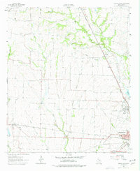
1962 Map of Greenville NW
USGS Topo · Published 1977About this map
Greenville and its northwestern rural surroundings are defined by a converging network of railroads and the upper reaches of the Sabine River system in the early 1960s. The landscape is etched with local history, featuring rural communities like Floyd and Kingston, alongside genealogy-rich sites such as Barnhart Boles Cem and Money Cem. The industrial and social backbone of the era is evident in the rail lines of the Missouri Kansas Texas and Louisiana and Arkansas, which serviced the agricultural and growing urban center.
Find a feature on this map
31 named features on this map. Tap any name to fly to it.
Don’t see what you’re looking for? This feature index may not catch every label — zoom into the map to look around manually.
Map Details
Editions of this 1962 Greenville NW Map
2 editions found
Other maps of this area

1930 · Farmersville
USGS Topo · 1:62,500

1954 · Sherman
USGS Topo · 1:250,000

1958 · Sherman
USGS Topo · 1:250,000

1960 · Pike
USGS Topo · 1:24,000

1962 · Greenville NW
USGS Topo · 1:24,000

1962 · Greenville SW
USGS Topo · 1:24,000

1962 · Greenville SE
USGS Topo · 1:24,000

1962 · Farmersville
USGS Topo · 1:24,000

1963 · Greenville NE
USGS Topo · 1:24,000
1963 · Josephine
USGS Topo · 1:24,000