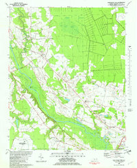
1982 Map of Greenville NW
USGS Topo · Published 1982About this map
The Tar River defines the southern reach of this landscape, meandering past Center Bluff and Clark Banks toward the growing outskirts of Greenville. In the early 1980s, this region of Pitt County maintained a distinct rural character, dominated by the expansive Grindle Pocosin and the Great Swamp to the north. A significant international communications landmark, the Edward R Murrow Transmitting Station of Voice of America (USIA), occupies a large tract in the southwest, reflecting the area's role in Cold War-era broadcasting. Small crossroads communities like Belvoir and Tyson are anchored by local institutions such as Gum Swamp Ch and Holly Hill Ch. The mapping also captures the Pitt - Greenville Airport and several cemeteries, providing a detailed look at the transition from swampy lowlands to established settlement patterns and essential infrastructure during this period.
Find a feature on this map
35 named features on this map. Tap any name to fly to it.
Don’t see what you’re looking for? This feature index may not catch every label — zoom into the map to look around manually.
Map Details
Editions of this 1982 Greenville NW Map
This is the sole edition of this map. No revisions or reprints were ever made.
Other maps of this area

1901 · Parmele
USGS Topo · 1:62,500

1902 · Parmele
USGS Topo · 1:62,500

1902 · Tarboro
USGS Topo · 1:62,500

1903 · Tarboro
USGS Topo · 1:62,500

1903 · Winterville
USGS Topo · 1:62,500

1904 · Falkland
USGS Topo · 1:62,500

1905 · Winterville
USGS Topo · 1:62,500

1953 · Rocky Mount
USGS Topo · 1:250,000

1954 · Rocky Mount
USGS Topo · 1:250,000

1980 · Falkland
USGS Topo · 1:24,000