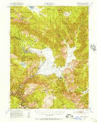
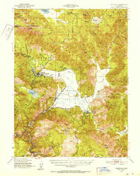
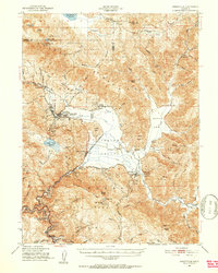
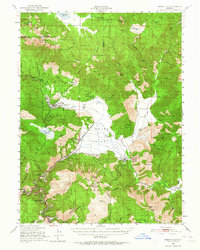
1950 Map of Greenville
USGS Topo · Published 1957About this map
Greenville and Taylorsville anchor the broad agricultural and ranching landscape of Indian Valley at the midpoint of the twentieth century. This survey documents a complex network of resource extraction and local heritage, ranging from the Engel Mine in the north to the Taylorsville Rancheria and Greenville Rancheria. The valley floor is crisscrossed by irrigation ditches and the Western Pacific railroad, which follows the winding course of Indian Creek through the mountains.
Find a feature on this map
69 named features on this map. Tap any name to fly to it.
Don’t see what you’re looking for? This feature index may not catch every label — zoom into the map to look around manually.
Map Details
Editions of this 1950 Greenville Map
4 editions found
Other maps of this area

1886 · Honey Lake
USGS Topo · 1:250,000

1886 · Lassen Peak
USGS Topo · 1:250,000

1888 · Bidwell Bar
USGS Topo · 1:125,000

1891 · Bidwell Bar
USGS Topo · 1:125,000

1891 · Downieville
USGS Topo · 1:125,000

1891 · Honey Lake
USGS Topo · 1:250,000

1892 · Lassen Peak
USGS Topo · 1:250,000

1893 · Bidwell Bar
USGS Topo · 1:125,000

1893 · Honey Lake
USGS Topo · 1:250,000

1893 · Downieville
USGS Topo · 1:125,000