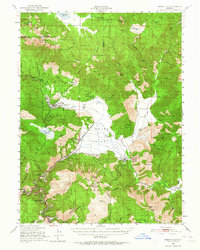
1950 Map of Greenville
USGS Topo · Published 1964About this map
Indian Valley serves as the central hub of this 1950s-era landscape, where the agricultural flats of Taylorsville and Greenville meet the industrial activities of the northern Sierras. The Western Pacific railroad tracks follow the winding canyon of Wolf Creek, connecting settlements like Crescent Mills and Keddie. The map reveals a robust mining history with numerous operations scattered across the hills, including the Engel Mine near Moonlight Valley and the Indian Valley Mine. Indigenous presence and historical community sites are clearly marked at the Greenville Rancheria, Taylorsville Rancheria, and the Indian Mission. The terrain transitions from the high peaks of Grizzly Mtn and Mt Hough Lookout down into the narrow, creek-fed corridors of Genesee Valley.
Find a feature on this map
97 named features on this map. Tap any name to fly to it.
Don’t see what you’re looking for? This feature index may not catch every label — zoom into the map to look around manually.
Map Details
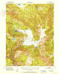
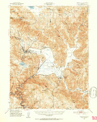
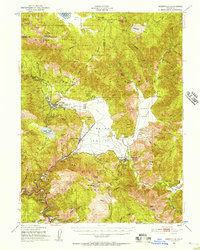
Editions of this 1950 Greenville Map
4 editions found
Other maps of this area

1886 · Honey Lake
USGS Topo · 1:250,000

1886 · Lassen Peak
USGS Topo · 1:250,000

1888 · Bidwell Bar
USGS Topo · 1:125,000

1891 · Bidwell Bar
USGS Topo · 1:125,000

1891 · Downieville
USGS Topo · 1:125,000

1891 · Honey Lake
USGS Topo · 1:250,000

1892 · Lassen Peak
USGS Topo · 1:250,000

1893 · Bidwell Bar
USGS Topo · 1:125,000

1893 · Honey Lake
USGS Topo · 1:250,000

1893 · Downieville
USGS Topo · 1:125,000