
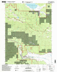
1994 Map of Greenville
USGS Topo · Published 1998About this map
Greenville serves as the primary hub in this mountain corridor, situated at the edge of the Indian Valley Creek floor. The landscape is a complex intersection of the Lassen National Forest and Plumas National Forest, reflecting a legacy of resource extraction and thermal activity. Local industry is evidenced by the Red Rock Mine, Indian Valley Mine, and New York Mine, while the Indian Valley Hot Springs and Peter Lassen Springs highlight the area's hydrothermal character. Notable local infrastructure includes the High Sch, the town Cemetery, and the Indian Valley Hospital Heliport. Further north, the high-elevation basin of Mountain Meadows is dominated by the Mountain Meadows Reservoir, surrounded by prominent peaks like Keddie Peak and the Eagle Lake Mount Hough ridge.
Find a feature on this map
39 named features on this map. Tap any name to fly to it.
Don’t see what you’re looking for? This feature index may not catch every label — zoom into the map to look around manually.
Map Details
Editions of this 1994 Greenville Map
2 editions found
Other maps of this area

1886 · Honey Lake
USGS Topo · 1:250,000

1886 · Lassen Peak
USGS Topo · 1:250,000

1891 · Honey Lake
USGS Topo · 1:250,000

1892 · Lassen Peak
USGS Topo · 1:250,000

1893 · Honey Lake
USGS Topo · 1:250,000

1894 · Lassen Peak
USGS Topo · 1:250,000
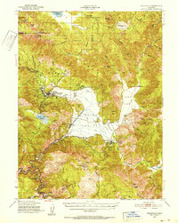
1950 · Greenville
USGS Topo · 1:62,500
1955 · Westwood
USGS Topo · 1:62,500
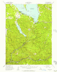
1955 · Almanor
USGS Topo · 1:62,500

1955 · Westwood
USGS Topo · 1:250,000