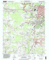
1998 Map of Greenville SW
USGS Topo · Published 2001About this map
The southern portion of Greenville and the town of Winterville anchor this landscape during a period of significant suburban expansion in Pitt County. Residential developments like Candlewick Estates and Westhaven reflect the outward growth from the city center, while smaller communities such as Frog Level and Dixons Crossroads maintain their rural identity. The map provides a detailed look at the local educational and religious infrastructure of the late 20th century, noting numerous neighborhood institutions like the Sadie Saulter Sch, Robinson Sch, and Good Hope Ch.
Find a feature on this map
60 named features on this map. Tap any name to fly to it.
Don’t see what you’re looking for? This feature index may not catch every label — zoom into the map to look around manually.
Map Details
Editions of this 1998 Greenville SW Map
This is the sole edition of this map. No revisions or reprints were ever made.
Other maps of this area

1902 · Ayden
USGS Topo · 1:62,500

1903 · Winterville
USGS Topo · 1:62,500

1904 · Ayden
USGS Topo · 1:62,500

1904 · Falkland
USGS Topo · 1:62,500

1905 · Winterville
USGS Topo · 1:62,500

1914 · Kinston
USGS Topo · 1:48,000

1916 · Kinston
USGS Topo · 1:62,500

1953 · Rocky Mount
USGS Topo · 1:250,000

1954 · Rocky Mount
USGS Topo · 1:250,000

1980 · Falkland
USGS Topo · 1:24,000