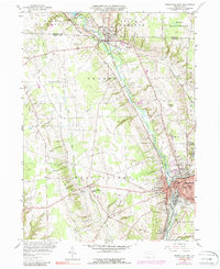
1958 Map of Greenville West
USGS Topo · Published 1988About this map
Greenville serves as the primary urban hub in this western Pennsylvania landscape, where the Shenango River and the Little Shenango River converge. The industrial and educational character of the borough is evident in the mid-century layout, featuring Thiel College, Penn High Sch, and the presence of significant infrastructure like the Sewage Disposal and a Substation. Transportation corridors dominate the eastern half of the map, with the Penn Central and Erie-Lackawanna railroads facilitating movement through the river valley.
Find a feature on this map
43 named features on this map. Tap any name to fly to it.
Don’t see what you’re looking for? This feature index may not catch every label — zoom into the map to look around manually.
Map Details
Editions of this 1958 Greenville West Map
4 editions found
Other maps of this area

1905 · Andover
USGS Topo · 1:48,000

1906 · Linesville
USGS Topo · 1:62,500

1907 · Andover
USGS Topo · 1:62,500

1907 · Kinsman
USGS Topo · 1:62,500

1908 · Shenango
USGS Topo · 1:62,500

1908 · Linesville
USGS Topo · 1:62,500

1950 · Cleveland
USGS Topo · 1:250,000

1956 · Cleveland
USGS Topo · 1:250,000

1958 · Sharpsville
USGS Topo · 1:24,000

1958 · Greensville West
USGS Topo · 1:24,000
Featured Places
- Greenville, PA
- Shenango, West Salem Township
- Jamestown, PA
- West Fallowfield Township, PA
- Donner Crossroads, West Salem Township