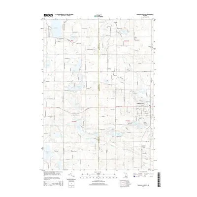
2014 Map of Greenville West
USGS Topo · Published 2014About this map
The Greenville area and the village of Gowen sit at the center of this 2014 survey, where the winding Flat River defines the local drainage. This portion of the Michigan landscape is characterized by a high density of water bodies, ranging from the large Wabasis Lake in the southwest to clusters including Woodbeck Lake, Ziegenfuss Lake, and Lincoln Lake. The map details the rural infrastructure connecting Kent and Montcalm counties, showing a transition from the structured residential streets of the city to the expansive township grids defined by roads like 14 Mile Rd NE and Wise Rd.
Find a feature on this map
164 named features on this map. Tap any name to fly to it.
Don’t see what you’re looking for? This feature index may not catch every label — zoom into the map to look around manually.
Map Details
Editions of this 2014 Greenville West Map
This is the sole edition of this map. No revisions or reprints were ever made.
Other maps of this area

1954 · Midland
USGS Topo · 1:250,000

1958 · Midland
USGS Topo · 1:250,000

1959 · Midland
USGS Topo · 1:250,000

1959 · Howard City
USGS Topo · 1:62,500

1964 · Langston
USGS Topo · 1:24,000

1966 · Midland
USGS Topo · 1:250,000

1972 · Greenville West
USGS Topo · 1:24,000
1972 · Belding
USGS Topo · 1:24,000
1972 · Greenville East
USGS Topo · 1:24,000
1972 · Evans
USGS Topo · 1:24,000