
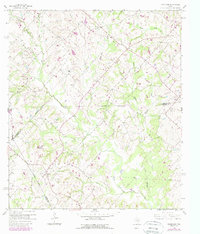
1958 Map of Greenvine
USGS Topo · Published 1959About this map
Greenvine and Latium anchor this rural landscape in the late 1950s, a region defined by its dispersed agricultural settlements and extensive creek networks. The terrain is deeply carved by the West Fork Mill Creek and Dogwood Creek, revealing a pattern of small farmsteads and family-named cemeteries that speak to the area’s German and European heritage. Genealogists can find several burial grounds, including the Jaeger Witte Cem, Mayer Cem, and Schmidt Cem, scattered across the undulating countryside.
Find a feature on this map
26 named features on this map. Tap any name to fly to it.
Don’t see what you’re looking for? This feature index may not catch every label — zoom into the map to look around manually.
Map Details
Editions of this 1958 Greenvine Map
2 editions found
Other maps of this area

1919 · Fayettsville
USGS Topo · 1:62,500

1930 · Brenham
USGS Topo · 1:62,500

1953 · Seguin
USGS Topo · 1:250,000

1954 · Austin
USGS Topo · 1:250,000

1956 · Bellville
USGS Topo · 1:62,500

1956 · Brenham
USGS Topo · 1:62,500

1958 · Seguin
USGS Topo · 1:250,000

1958 · Industry
USGS Topo · 1:24,000

1958 · Carmine
USGS Topo · 1:24,000
1958 · Fayetteville
USGS Topo · 1:24,000