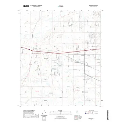
2020 Map of Greenwood
USGS Topo · Published 2020About this map
Greenwood and Flournoy anchor this Caddo Parish landscape as it appeared in 2020, where the westward expansion of Shreveport meets the rural townships of the Louisiana-Texas borderlands. The area is defined by its deep genealogical roots, preserved in numerous burial grounds such as the Bayliss Grave Yard, Old Oak Hill Church Cem, and the Jackson Pine Hill Cem. The terrain is characterized by the winding courses of Page Bayou and Boggy Bayou, which drain the low-lying areas near Lake Hayes. Significant infrastructure like the Bert Kouns Industrial Loop and numerous parish roads illustrate the intersection of historical settlement patterns with modern industrial and residential development. Local landmarks such as the Lincoln Memorial Park and the Bethlehem Missionary Baptist Church provide further evidence of the community's established social and religious history.
Find a feature on this map
119 named features on this map. Tap any name to fly to it.
Don’t see what you’re looking for? This feature index may not catch every label — zoom into the map to look around manually.
Map Details
Editions of this 2020 Greenwood Map
This is the sole edition of this map. No revisions or reprints were ever made.
Other maps of this area

1932 · Shreveport SE
USGS Topo · 1:31,680

1943 · Waskom
USGS Topo · 1:62,500

1944 · Caddo Lake
USGS Topo · 1:62,500

1945 · Waskom
USGS Topo · 1:62,500

1945 · Greenwood
USGS Topo · 1:62,500

1946 · Caddo Lake
USGS Topo · 1:62,500

1948 · Mooringsport
USGS Topo · 1:62,500

1955 · Shreveport
USGS Topo · 1:250,000
1955 · North Shreveport
USGS Topo · 1:24,000
1955 · Shreveport West
USGS Topo · 1:24,000