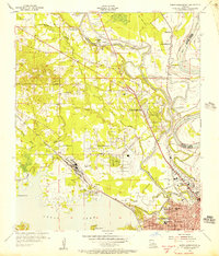
1955 Map of North Shreveport
USGS Topo · Published 1956About this map
The northern edge of Shreveport meets the industrial and agricultural landscape of Caddo Parish in this mid-1950s study. The Red River and Twelvemile Bayou define the hydrology here, with the Twelvemile Bayou Waterway Project and a complex system of levees and borrow pits indicating active flood control and navigation efforts. Transportation is dominated by the Texas and Pacific and Kansas City Southern railroads, which service the growing suburbs and the Shreveport Oil Field.
Find a feature on this map
54 named features on this map. Tap any name to fly to it.
Don’t see what you’re looking for? This feature index may not catch every label — zoom into the map to look around manually.
Map Details
Editions of this 1955 North Shreveport Map
This is the sole edition of this map. No revisions or reprints were ever made.
Other maps of this area

1932 · Bossier SW
USGS Topo · 1:31,680

1932 · Shreveport SE
USGS Topo · 1:31,680

1932 · Bossier NW
USGS Topo · 1:31,680

1932 · Shreveport NE
USGS Topo · 1:31,680

1941 · Forbing
USGS Topo · 1:31,680

1945 · Greenwood
USGS Topo · 1:62,500

1948 · Mooringsport
USGS Topo · 1:62,500

1948 · Bossier City
USGS Topo · 1:62,500

1948 · Caspiana
USGS Topo · 1:62,500

1955 · Shreveport
USGS Topo · 1:250,000