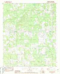
1982 Map of Greenwood
USGS Topo · Published 1982About this map
The town of Greenwood sits west of the expanding Shreveport corporate boundary in this early 1980s survey of Caddo Parish. The landscape is defined by its complex drainage systems, featuring the winding paths of Cross Bayou, Page Bayou, and Boggy Bayou. These waterways, along with Lake Hayes, represent the characteristic lowland terrain of northwestern Louisiana before further suburbanization. Industrial and utility footprints are evident through several Cem locations and infrastructure markers like the Radio Tower and Sub Sta.
Find a feature on this map
17 named features on this map. Tap any name to fly to it.
Don’t see what you’re looking for? This feature index may not catch every label — zoom into the map to look around manually.
Map Details
Editions of this 1982 Greenwood Map
This is the sole edition of this map. No revisions or reprints were ever made.
Other maps of this area

1932 · Shreveport SE
USGS Topo · 1:31,680

1943 · Waskom
USGS Topo · 1:62,500

1944 · Caddo Lake
USGS Topo · 1:62,500

1945 · Waskom
USGS Topo · 1:62,500

1945 · Greenwood
USGS Topo · 1:62,500

1946 · Caddo Lake
USGS Topo · 1:62,500

1948 · Mooringsport
USGS Topo · 1:62,500

1955 · Shreveport
USGS Topo · 1:250,000
1955 · North Shreveport
USGS Topo · 1:24,000
1955 · Shreveport West
USGS Topo · 1:24,000