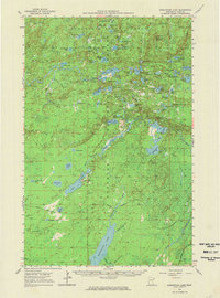
1954 Map of Greenwood Lake
USGS Topo · Published 1975About this map
The Erie Mining Company Railroad cuts across the southern portion of this landscape, marking the industrial activity of the mid-1950s within the Superior National Forest. This region of northeastern Minnesota is defined by an intricate network of waterways including the Stony River and Kelly Creek, which connect dozens of named lakes such as Slate Lake, Dunnigan Lake, and the remote Dragon Lake. Topographic landmarks like Jack Pine Mountain and the elongated height of Ridgepole rise above the basin, while numerous Gravel Pits indicate the infrastructure development occurring during this period. The survey captures a moment when industrial transport and forestry intersected, evidenced by the railroad's path near Homestead Cr and its progression through the dense lake country.
Find a feature on this map
66 named features on this map. Tap any name to fly to it.
Don’t see what you’re looking for? This feature index may not catch every label — zoom into the map to look around manually.
Map Details
Editions of this 1954 Greenwood Lake Map
2 editions found
Other maps of this area

1933 · Ely
USGS Topo · 1:62,500

1939 · Ely
USGS Topo · 1:62,500

1952 · Babbitt SE
USGS Topo · 1:24,000

1952 · Babbitt NE
USGS Topo · 1:24,000

1953 · Whyte
USGS Topo · 1:62,500

1954 · Greenwood Lake
USGS Topo · 1:62,500

1954 · Silver Bay
USGS Topo · 1:62,500

1954 · Two Harbors
USGS Topo · 1:250,000

1955 · Isabella
USGS Topo · 1:62,500

1957 · Two Harbors
USGS Topo · 1:250,000