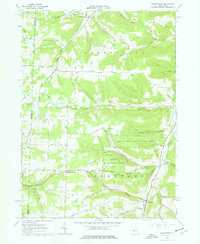
1965 Map of Greenwood
USGS Topo · Published 1977About this map
Greenwood and Hartsville anchor this 1965 survey of the southern Tier, a landscape defined by the deep incisions of Bennetts Creek and Dyke Creek. The terrain is marked by a legacy of resource extraction, with numerous Oil Wells and Pumping Stations scattered across the southwestern hills near West Greenwood. This industrial footprint contrasts with large tracts of the State Reforestation Area, which preserve the steep slopes of the creek valleys.
Find a feature on this map
58 named features on this map. Tap any name to fly to it.
Don’t see what you’re looking for? This feature index may not catch every label — zoom into the map to look around manually.
Map Details
Editions of this 1965 Greenwood Map
2 editions found
Other maps of this area

1915 · Hornell
USGS Topo · 1:62,500

1916 · Canaseraga
USGS Topo · 1:62,500

1918 · Hornell
USGS Topo · 1:62,500

1926 · Wellsville
USGS Topo · 1:62,500

1926 · Greenwood
USGS Topo · 1:62,500

1940 · Canaseraga
USGS Topo · 1:62,500

1950 · Elmira
USGS Topo · 1:250,000

1954 · South Canisteo
USGS Topo · 1:24,000

1954 · Troupsburg
USGS Topo · 1:24,000
1954 · Canisteo
USGS Topo · 1:24,000