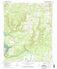
1973 Map of Greers Ferry Dam
USGS Topo · Published 1975About this map
Greers Ferry Dam dominates the southwestern corner of this landscape, holding back the waters of Greers Ferry Lake as they transition into the Little Red River. The 1973 survey details the area just below the dam, where the National Fish Hatchery and several recreation areas are established. Further inland, the map captures the rural character of Cleburne County, from the small settlements of Ida and Wilburn to the scattered country congregations at Antioch Ch and Pleasant Ridge Ch.
Find a feature on this map
49 named features on this map. Tap any name to fly to it.
Don’t see what you’re looking for? This feature index may not catch every label — zoom into the map to look around manually.
Map Details
Editions of this 1973 Greers Ferry Dam Map
2 editions found
Other maps of this area

1890 · Batesville
USGS Topo · 1:125,000

1891 · Batesville
USGS Topo · 1:125,000

1892 · Mountain View
USGS Topo · 1:125,000

1894 · Mountain View
USGS Topo · 1:125,000

1942 · Almond
USGS Topo · 1:31,680

1953 · Memphis
USGS Topo · 1:250,000

1956 · Memphis
USGS Topo · 1:250,000

1956 · Russellville
USGS Topo · 1:250,000

1962 · Pangburn
USGS Topo · 1:24,000

1963 · West Pangburn
USGS Topo · 1:24,000