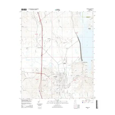
2015 Map of Grenada
USGS Topo · Published 2015About this map
Grenada serves as the central hub of this survey, situated where the Yalobusha River meets the winding Batupan Bogue. The town grid is detailed with street names such as Telegraph St, Springhill Rd, and Margin St, reflecting its historical development as a regional center of commerce and transport. The landscape is marked by the influence of the river and the proximity of Grenada Lake to the northeast, which has shaped the settlement patterns at Grenada Landing and Cedar Point.
Find a feature on this map
119 named features on this map. Tap any name to fly to it.
Don’t see what you’re looking for? This feature index may not catch every label — zoom into the map to look around manually.
Map Details
Editions of this 2015 Grenada Map
This is the sole edition of this map. No revisions or reprints were ever made.
Other maps of this area

1953 · West Point
USGS Topo · 1:250,000

1954 · Grenada
USGS Topo · 1:62,500

1954 · Duck Hill
USGS Topo · 1:62,500

1954 · McCarley
USGS Topo · 1:62,500

1955 · Coffeeville
USGS Topo · 1:62,500

1958 · West Point
USGS Topo · 1:250,000

1963 · West Point
USGS Topo · 1:250,000
1971 · Coffeeville
USGS Topo · 1:24,000
1983 · Tie Plant
USGS Topo · 1:24,000
1983 · Jefferson
USGS Topo · 1:24,000