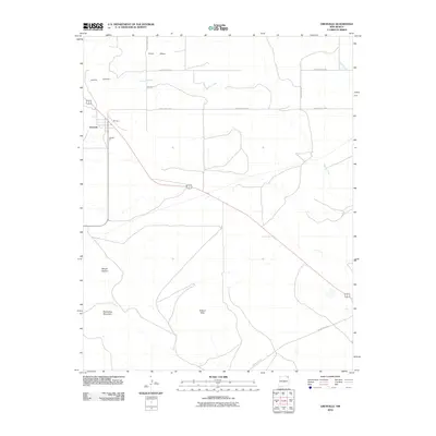
2010 Map of Grenville
USGS Topo · Published 2010About this map
Grenville and the nearby settlement of Marquez anchor this high-plains landscape in Union County, New Mexico. The geography is defined by volcanic features and distinct drainage patterns, including the prominent peaks of Mount Clayton and Horseshoe Mountain which rise above the surrounding Kilburn Hills. The local economy and land use are reflected in the presence of the Seneca Pit mine and an extensive network of rural routes such as County Hwy A-059. Arid watercourses like Seneca Creek and Alamos Creek carve through the terrain, while Sand Mesa and Cherry Canyon provide further topographical variation to this sparsely populated cattle-country region during the early twenty-first century.
Find a feature on this map
17 named features on this map. Tap any name to fly to it.
Don’t see what you’re looking for? This feature index may not catch every label — zoom into the map to look around manually.
Map Details
Editions of this 2010 Grenville Map
This is the sole edition of this map. No revisions or reprints were ever made.
Other maps of this area

1954 · Dalhart
USGS Topo · 1:250,000

1958 · Dalhart
USGS Topo · 1:250,000

1962 · Dalhart
USGS Topo · 1:250,000

1966 · Black Canyon
USGS Topo · 1:24,000

1972 · Mount Dora
USGS Topo · 1:24,000
1972 · Boiler Gap
USGS Topo · 1:24,000
1973 · Wetherly Lake
USGS Topo · 1:24,000

1973 · Grenville SW
USGS Topo · 1:24,000

1973 · Snyder Lake
USGS Topo · 1:24,000

1973 · Tripod Mountain
USGS Topo · 1:24,000