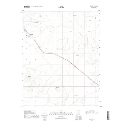
2020 Map of Grenville
USGS Topo · Published 2020About this map
Grenville serves as the primary settlement on this Union County landscape, situated along the northern section of the survey. The community's local infrastructure is detailed through specific street labels like Burlington St, 1st St, and 5th St, as well as a central Po marker. The surrounding terrain is defined by dramatic volcanic and mesa formations, notably Mt Clayton and the crescent-shaped Horseshoe Mtn in the southwest corner. The drainage pattern is dominated by the winding paths of Seneca Cr and Alamos Cr, which cut through the high plains. Extensive ranching or maintenance routes such as Sand Mesa Rd, Blind Gap Rd, and Wiseman Rd create a grid-like network across the expansive elevations of Sand Mesa and the Kilburn Hills, illustrating the low-density, wide-open character of this northeastern New Mexico region.
Find a feature on this map
26 named features on this map. Tap any name to fly to it.
Don’t see what you’re looking for? This feature index may not catch every label — zoom into the map to look around manually.
Map Details
Editions of this 2020 Grenville Map
This is the sole edition of this map. No revisions or reprints were ever made.
Other maps of this area

1954 · Dalhart
USGS Topo · 1:250,000

1958 · Dalhart
USGS Topo · 1:250,000

1962 · Dalhart
USGS Topo · 1:250,000

1966 · Black Canyon
USGS Topo · 1:24,000

1972 · Mount Dora
USGS Topo · 1:24,000
1972 · Boiler Gap
USGS Topo · 1:24,000
1973 · Wetherly Lake
USGS Topo · 1:24,000

1973 · Grenville SW
USGS Topo · 1:24,000

1973 · Snyder Lake
USGS Topo · 1:24,000

1973 · Tripod Mountain
USGS Topo · 1:24,000