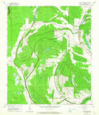
1963 Map of Gretna Green
USGS Topo · Published 1964About this map
Big Choctaw Bayou and its numerous oxbow lakes dominate this Tensas Parish landscape in the early 1960s, illustrating the complex hydrology of the Mississippi Delta region. The map documents a rural society structured around water and agriculture, from the Wavertree Plantation in the south to smaller clusters like Shady Grove and Gretna Green. A notable concentration of community landmarks, such as New China Grove Ch, Monclova Ch, and the Mayflower Cem, highlights the importance of local congregations in this era. The terrain is marked by prehistoric features including several Indian Mounds, while the 20th-century economy is visible through numerous Drill Holes and Oil Wells scattered across the fields. The presence of the St Peter Canal and Van Buren road suggests the evolving transportation network designed to navigate this wetland-rich environment.
Find a feature on this map
46 named features on this map. Tap any name to fly to it.
Don’t see what you’re looking for? This feature index may not catch every label — zoom into the map to look around manually.
Map Details
Editions of this 1963 Gretna Green Map
2 editions found
Other maps of this area

1909 · Delta Bridge
USGS Topo · 1:24,000

1935 · Winnsboro
USGS Topo · 1:62,500

1935 · Shackleford Lake
USGS Topo · 1:62,500

1939 · Locust Ridge
USGS Topo · 1:62,500

1941 · Sicily Island
USGS Topo · 1:62,500

1953 · Natchez
USGS Topo · 1:250,000

1955 · Jackson
USGS Topo · 1:250,000

1956 · Natchez
USGS Topo · 1:250,000

1957 · Sicily Island
USGS Topo · 1:62,500

1958 · Shackleford Lake
USGS Topo · 1:62,500