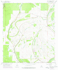
1963 Map of Gretna Green
USGS Topo · Published 1977About this map
Wavertree Plantation and the surrounding river bottomlands of Tensas Parish define this landscape in the mid-1960s. The area is heavily marked by the winding courses of Big Choctaw Bayou and Little Choctaw Bayou, which have left behind numerous oxbows and depressions such as Turkey Lake, Snodgrass Lake, and Formosa Lake. The map reveals a community structured around these waterways and the Van Buren Road, with several rural congregations including New China Grove Ch, Monclova Ch, and New Zion Ch.
Find a feature on this map
47 named features on this map. Tap any name to fly to it.
Don’t see what you’re looking for? This feature index may not catch every label — zoom into the map to look around manually.
Map Details
Editions of this 1963 Gretna Green Map
2 editions found
Other maps of this area

1909 · Delta Bridge
USGS Topo · 1:24,000

1935 · Winnsboro
USGS Topo · 1:62,500

1935 · Shackleford Lake
USGS Topo · 1:62,500

1939 · Locust Ridge
USGS Topo · 1:62,500

1941 · Sicily Island
USGS Topo · 1:62,500

1953 · Natchez
USGS Topo · 1:250,000

1955 · Jackson
USGS Topo · 1:250,000

1956 · Natchez
USGS Topo · 1:250,000

1957 · Sicily Island
USGS Topo · 1:62,500

1958 · Shackleford Lake
USGS Topo · 1:62,500