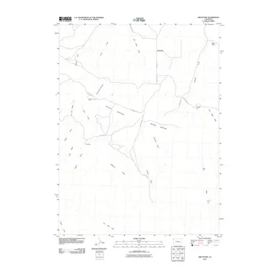
2010 Map of Greystone
USGS Topo · Published 2010About this map
Greystone and its surrounding ranchlands sit at a crossroads of high-desert geography where Douglas Mountain and Limestone Ridge dictate the movement of local travel. The settlement patterns of this Moffat County landscape are defined by isolated outposts like Whiskey Springs Ranch and Tepee Ranch, which are positioned near essential water sources and sheltered valleys. The terrain is deeply incised by a network of seasonal drainages, including Rye Grass Draw and Douglas Draw, which converge toward the higher elevations of Smelter Hill and the sprawling John Weller Mesa. Industrial history is etched into the names of the land, with features such as Iron Mine Basin and Smelter Hill hinting at the mineral extraction that helped shape the region's development. Access across this topography relies on a system of county roads, such as County Rd-116, which threads through Dutch Oven Canyon to connect these remote ranching hubs.
Find a feature on this map
30 named features on this map. Tap any name to fly to it.
Don’t see what you’re looking for? This feature index may not catch every label — zoom into the map to look around manually.
Map Details
Editions of this 2010 Greystone Map
This is the sole edition of this map. No revisions or reprints were ever made.
Other maps of this area

1907 · Rangely
USGS Topo · 1:125,000

1910 · Rangely
USGS Topo · 1:125,000

1954 · Vernal
USGS Topo · 1:250,000

1958 · Vernal
USGS Topo · 1:250,000

1960 · Vernal
USGS Topo · 1:250,000

1962 · Tanks Peak
USGS Topo · 1:24,000

1962 · Indian Water Canyon
USGS Topo · 1:24,000
1962 · Haystack Rock
USGS Topo · 1:24,000
1966 · Limestone Hill
USGS Topo · 1:24,000

1966 · Sheephead Basin
USGS Topo · 1:24,000