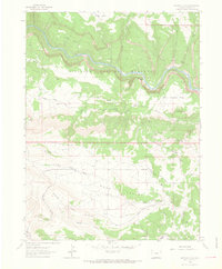
1962 Map of Haystack Rock
USGS Topo · Published 1966About this map
The Yampa River carves a deep, winding path through the northern reaches of this Colorado landscape, where much of the river's canyon system is protected within Dinosaur National Monument. This area is defined by sharp topographic relief and isolated plateaus like West Cactus Flat and the prominent Haystack Rock. Human activity in this remote terrain is centered around the Mantle Ranch, which is connected to the wider region by the primitive Mantle Ranch Road and several rugged trails.
Find a feature on this map
24 named features on this map. Tap any name to fly to it.
Don’t see what you’re looking for? This feature index may not catch every label — zoom into the map to look around manually.
Map Details
Editions of this 1962 Haystack Rock Map
2 editions found
Other maps of this area

1907 · Rangely
USGS Topo · 1:125,000

1910 · Rangely
USGS Topo · 1:125,000

1954 · Vernal
USGS Topo · 1:250,000

1958 · Vernal
USGS Topo · 1:250,000

1960 · Vernal
USGS Topo · 1:250,000

1962 · Lazy Y Point
USGS Topo · 1:24,000

1962 · Tanks Peak
USGS Topo · 1:24,000
1962 · M F Mountain
USGS Topo · 1:24,000
1962 · Skull Creek
USGS Topo · 1:24,000

1962 · Indian Water Canyon
USGS Topo · 1:24,000