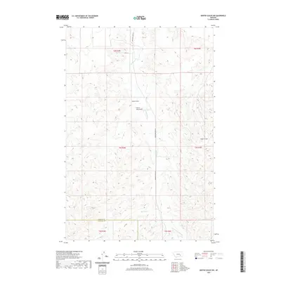
2020 Map of Griffin Coulee NW
USGS Topo · Published 2020About this map
Reservation Creek Rd and Jones Ln provide the primary access through this dissected landscape where the boundaries of Rosebud Co and Treasure Co meet. The terrain is defined by a dense network of coulees and intermittent streams that drain toward larger regional basins. Among these prominent drainage features are Cache Coulee, Prairie Dog Coulee, and Wyant Coulee, each carving distinct paths through the high plains. The map illustrates the sophisticated Public Land Survey System (PLSS) grid, with sections clearly marked within t6n r38e and t5n r39e, reflecting the orderly division of the American West. Hydrological features such as Reservation Cr and Blacktail Cr highlight the reliance on natural watercourses in this arid environment, providing essential context for land use and ranching history in this part of Montana.
Find a feature on this map
17 named features on this map. Tap any name to fly to it.
Don’t see what you’re looking for? This feature index may not catch every label — zoom into the map to look around manually.
Map Details
Editions of this 2020 Griffin Coulee NW Map
This is the sole edition of this map. No revisions or reprints were ever made.
Other maps of this area

1954 · Forsyth
USGS Topo · 1:250,000

1957 · Forsyth
USGS Topo · 1:250,000

1958 · Forsyth
USGS Topo · 1:250,000

1960 · Sanders
USGS Topo · 1:24,000

1968 · Nichols
USGS Topo · 1:24,000

1968 · Finch
USGS Topo · 1:24,000

1971 · Griffin Coulee SW
USGS Topo · 1:24,000

1971 · Griffin Coulee NE
USGS Topo · 1:24,000
1971 · Griffin Coulee
USGS Topo · 1:24,000
1971 · Griffin Coulee NW
USGS Topo · 1:24,000