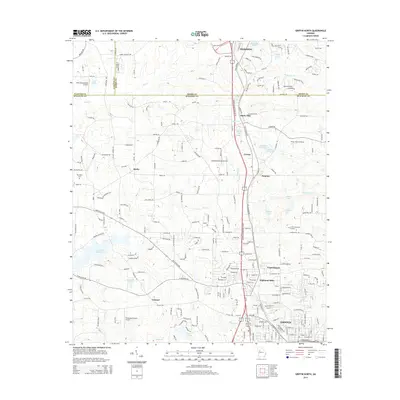
2014 Map of Griffin North
USGS Topo · Published 2014About this map
The northern reaches of Griffin and the historic settlement of Experiment anchor this study of the Georgia piedmont, where suburban growth meets a landscape defined by small-scale aviation and textile history. The map traces the industrial footprint of Highland Mills and the academic presence of Experiment, while the surrounding terrain is dotted with private landing strips like Halls Flying Ranch Airport and the Beaverbrook Aerodrome. Water management is central to the area's development, evidenced by the Heads Cr Reservoir and numerous family-named impoundments such as Cheatham Lake and Southern Fruit Lake. Small communities like Sunny Side, Pomona, and Birdie follow the corridor of the Old Highway, marking the transition between the established town centers of Hampton and the northern outskirts of Spalding County.
Find a feature on this map
226 named features on this map. Tap any name to fly to it.
Don’t see what you’re looking for? This feature index may not catch every label — zoom into the map to look around manually.
Map Details
Editions of this 2014 Griffin North Map
This is the sole edition of this map. No revisions or reprints were ever made.
Other maps of this area

1951 · Barnesville
USGS Topo · 1:62,500

1953 · Atlanta
USGS Topo · 1:250,000

1957 · Atlanta
USGS Topo · 1:250,000

1958 · Atlanta
USGS Topo · 1:250,000

1964 · Luella
USGS Topo · 1:24,000
1964 · Mc Donough
USGS Topo · 1:24,000
1965 · Hampton
USGS Topo · 1:24,000

1965 · Fayetteville
USGS Topo · 1:24,000

1965 · Griffin North
USGS Topo · 1:24,000

1965 · Brooks
USGS Topo · 1:24,000