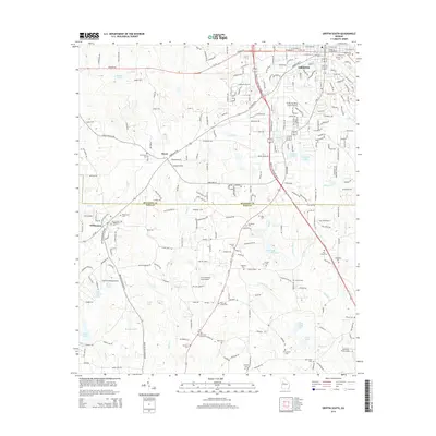
2014 Map of Griffin South
USGS Topo · Published 2014About this map
The southern outskirts of Griffin and the rural reaches of Spalding and Pike counties define this landscape, where the transition from urban streets to rolling farmland is marked by a dense network of aviation and local history. Multiple airstrips, including the Griffin-Spalding County Airport, Eagles Landing Airport, and the private Kitchens Field Airport, underscore the region's flight history. In the western portion, the small settlements of Williamson and Rover serve as focal points for rural life. Genealogists will find a wealth of family-named sites across the countryside, from Stonewall Cem and Oak Hill Cem in the north to the Pitts and Green Cem and D F Greene Cem further south. Waterways like Wasp Cr and Bevils Cr feed into numerous local impoundments such as Bevils Creek Lake and Johnson Lake.
Find a feature on this map
73 named features on this map. Tap any name to fly to it.
Don’t see what you’re looking for? This feature index may not catch every label — zoom into the map to look around manually.
Map Details
Editions of this 2014 Griffin South Map
This is the sole edition of this map. No revisions or reprints were ever made.
Other maps of this area

1951 · Barnesville
USGS Topo · 1:62,500

1953 · Atlanta
USGS Topo · 1:250,000

1957 · Atlanta
USGS Topo · 1:250,000

1958 · Atlanta
USGS Topo · 1:250,000

1964 · Luella
USGS Topo · 1:24,000

1965 · Griffin North
USGS Topo · 1:24,000

1965 · Brooks
USGS Topo · 1:24,000

1971 · Hollonville
USGS Topo · 1:24,000
1971 · Griffin South
USGS Topo · 1:24,000
1971 · Zebulon
USGS Topo · 1:24,000