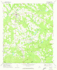
1971 Map of Zebulon
USGS Topo · Published 1973About this map
The Pike County seat of Zebulon serves as the focal point for this rural landscape in the early 1970s, where the Southern railroad line connects several small settlements and agricultural communities. To the southeast, Meansville is situated near the junction of Chapman Creek and Gola Creek, while the village of Lifsey sits further west along Powder Creek. The topography is defined by the transition from rolling farmland to the elevated terrain of Indian Grave Mountain in the south, a significant landmark overlooking Clearwater Springs and Threemile Creek.
Find a feature on this map
45 named features on this map. Tap any name to fly to it.
Don’t see what you’re looking for? This feature index may not catch every label — zoom into the map to look around manually.
Map Details
Editions of this 1971 Zebulon Map
2 editions found
Other maps of this area

1935 · Thomaston
USGS Topo · 1:48,000

1939 · Thomaston
USGS Topo · 1:62,500

1951 · Yatesville
USGS Topo · 1:62,500

1951 · Barnesville
USGS Topo · 1:62,500

1953 · Atlanta
USGS Topo · 1:250,000

1955 · Phenix City
USGS Topo · 1:250,000

1957 · Phenix City
USGS Topo · 1:250,000

1957 · Atlanta
USGS Topo · 1:250,000

1958 · Phenix City
USGS Topo · 1:250,000

1958 · Atlanta
USGS Topo · 1:250,000