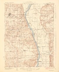
1926 Map of Griggsville
USGS Topo · Published 1926About this map
Illinois River commerce and drainage infrastructure dominate this mid-1920s landscape, where the wide river valley separates Pike and Scott Counties. The Wabash RR crosses the water at Valley City, a key transportation node supported by the Valley City Pumping Sta. The surrounding uplands are densely populated with small rural institutions, including dozens of country schoolhouses like Brush College School and Zion Neck School, alongside community centers such as Bethel Church.
Find a feature on this map
81 named features on this map. Tap any name to fly to it.
Don’t see what you’re looking for? This feature index may not catch every label — zoom into the map to look around manually.
Map Details
Editions of this 1926 Griggsville Map
2 editions found
Other maps of this area

1924 · Winchester
USGS Topo · 1:48,000

1924 · Roodhouse
USGS Topo · 1:62,500

1924 · Griggsville
USGS Topo · 1:62,500

1926 · Griggsville
USGS Topo · 1:62,500

1926 · Pittsfield
USGS Topo · 1:62,500

1926 · Winchester
USGS Topo · 1:62,500

1926 · Roodhouse
USGS Topo · 1:62,500

1926 · Mt Sterling
USGS Topo · 1:62,500

1928 · Meredosia
USGS Topo · 1:62,500

1929 · Mt Sterling
USGS Topo · 1:62,500