
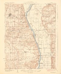
1926 Map of Griggsville
USGS Topo · Published 1926About this map
The Illinois River corridor defines this landscape, separating the rugged bluffs and creek-dissected hills of Pike County from the alluvial plains of Scott County. In the mid-1920s, the river was an industrial artery supported by facilities like the Valley City Pumping Sta and the Big Swan Pumping Sta, while the Wabash RR provided the primary land connection through the hub of Griggsville. Beyond the river valley, the terrain is characterized by a dense network of local landmarks, including family-named sites like Boss Wilson and Calvert Hill.
Find a feature on this map
79 named features on this map. Tap any name to fly to it.
Don’t see what you’re looking for? This feature index may not catch every label — zoom into the map to look around manually.
Map Details
Editions of this 1926 Griggsville Map
2 editions found
Other maps of this area

1924 · Winchester
USGS Topo · 1:48,000

1924 · Roodhouse
USGS Topo · 1:62,500

1924 · Griggsville
USGS Topo · 1:62,500

1926 · Pittsfield
USGS Topo · 1:62,500

1926 · Winchester
USGS Topo · 1:62,500

1926 · Roodhouse
USGS Topo · 1:62,500

1926 · Mt Sterling
USGS Topo · 1:62,500

1928 · Meredosia
USGS Topo · 1:62,500

1929 · Mt Sterling
USGS Topo · 1:62,500

1929 · Arenzville
USGS Topo · 1:62,500