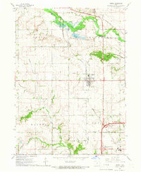
1965 Map of Grimes
USGS Topo · Published 1966About this map
Grimes sits at the heart of this mid-1960s landscape, serving as a hub for both agricultural activity and the intersecting lines of the Chicago Milwaukee St Paul and Pacific and the Chicago and North Western railroads. To the south, the Urbandale corporate boundary is visible, signaling the expanding reach of the Des Moines metropolitan area into the surrounding townships of Walnut and Webster. This era captures a transition from purely rural farmstead patterns to suburban development, with early industrial infrastructure such as the Sewage Disposal and Water Tank appearing near the town center.
Find a feature on this map
28 named features on this map. Tap any name to fly to it.
Don’t see what you’re looking for? This feature index may not catch every label — zoom into the map to look around manually.
Map Details
Editions of this 1965 Grimes Map
2 editions found
Other maps of this area

1905 · Des Moines
USGS Topo · 1:62,500

1907 · Des Moines
USGS Topo · 1:62,500

1908 · Waukee
USGS Topo · 1:62,500

1911 · Madrid
USGS Topo · 1:62,500

1911 · Slater
USGS Topo · 1:62,500

1913 · Slater
USGS Topo · 1:62,500

1914 · Madrid
USGS Topo · 1:62,500

1954 · Des Moines
USGS Topo · 1:250,000

1956 · Des Moines
USGS Topo · 1:250,000

1956 · Des Moines NW
USGS Topo · 1:24,000