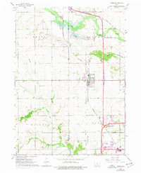
1965 Map of Grimes
USGS Topo · Published 1977About this map
Grimes sits at a crossroads of agriculture and early suburban expansion in this mid-1960s Iowa landscape. The town center is defined by its industrial roots, featuring a Sewage Disposal plant and Water Tank, while the residential fringe includes the Trailer Park and Sunny Hill area. Transportation corridors dominate the eastern half of the sheet, where the Chicago Milwaukee St Paul and Pacific railroad and the Des Moines and Central Iowa rail lines intersect the growing highway system at the Granger-Grimes Interchange.
Find a feature on this map
36 named features on this map. Tap any name to fly to it.
Don’t see what you’re looking for? This feature index may not catch every label — zoom into the map to look around manually.
Map Details
Editions of this 1965 Grimes Map
2 editions found
Other maps of this area

1905 · Des Moines
USGS Topo · 1:62,500

1907 · Des Moines
USGS Topo · 1:62,500

1908 · Waukee
USGS Topo · 1:62,500

1911 · Madrid
USGS Topo · 1:62,500

1911 · Slater
USGS Topo · 1:62,500

1913 · Slater
USGS Topo · 1:62,500

1914 · Madrid
USGS Topo · 1:62,500

1954 · Des Moines
USGS Topo · 1:250,000

1956 · Des Moines
USGS Topo · 1:250,000

1956 · Des Moines NW
USGS Topo · 1:24,000