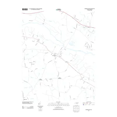
2013 Map of Grimesland
USGS Topo · Published 2013About this map
The Tar River snakes through the center of this landscape, its path mirrored by a network of low-lying wetlands including Cow Swamp and Cross Swamp. This area of Pitt County is defined by its rural crossroads and river-oriented settlements, where historic family and locality names like Yankee Hall, Bryan, and Latham anchor the geography. The town of Grimesland serves as a primary hub, situated near the river and connected to outlying rural communities like Hams Crossroads and Boyd Crossroads by a dense web of local roads. The inclusion of Boyd Field Airport and various creek systems such as Chicod Cr and Grindle Cr highlights the region's mix of aviation infrastructure and natural drainage. This topographic record captures the eastern North Carolina coastal plain at a time when traditional agricultural land patterns remained prominent even as modern transportation networks expanded through the river corridor.
Find a feature on this map
115 named features on this map. Tap any name to fly to it.
Don’t see what you’re looking for? This feature index may not catch every label — zoom into the map to look around manually.
Map Details
Editions of this 2013 Grimesland Map
This is the sole edition of this map. No revisions or reprints were ever made.
Other maps of this area

1902 · Ayden
USGS Topo · 1:62,500

1902 · Vanceboro
USGS Topo · 1:62,500

1903 · Winterville
USGS Topo · 1:62,500

1903 · Chocowinity
USGS Topo · 1:62,500

1904 · Ayden
USGS Topo · 1:62,500

1904 · Vanceboro
USGS Topo · 1:62,500

1905 · Chocowinity
USGS Topo · 1:62,500

1905 · Winterville
USGS Topo · 1:62,500

1905 · Vanceboro
USGS Topo · 1:62,500

1951 · Hackney
USGS Topo · 1:24,000