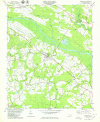
1979 Map of Grimesland
USGS Topo · Published 1980About this map
Grimesland sits as a primary rail and road hub in this late 1970s landscape, positioned where the Norfolk Southern line bisects the territory. The surrounding coastal plain is defined by a dense network of watercourse drainage including Chicod Creek, Bear Creek, and Grindle Creek, all feeding into the meandering Tar River. This riverine environment supported early riverfront locations like Yankee Hall and Pactolus, while the interior shows a transition toward timber and agriculture, evidenced by naming conventions for expansive wetlands like Chicod Swamp and Cow Swamp.
Find a feature on this map
39 named features on this map. Tap any name to fly to it.
Don’t see what you’re looking for? This feature index may not catch every label — zoom into the map to look around manually.
Map Details
Editions of this 1979 Grimesland Map
This is the sole edition of this map. No revisions or reprints were ever made.
Other maps of this area

1902 · Ayden
USGS Topo · 1:62,500

1902 · Vanceboro
USGS Topo · 1:62,500

1903 · Winterville
USGS Topo · 1:62,500

1903 · Chocowinity
USGS Topo · 1:62,500

1904 · Ayden
USGS Topo · 1:62,500

1904 · Vanceboro
USGS Topo · 1:62,500

1905 · Chocowinity
USGS Topo · 1:62,500

1905 · Winterville
USGS Topo · 1:62,500

1905 · Vanceboro
USGS Topo · 1:62,500

1951 · Hackney
USGS Topo · 1:24,000