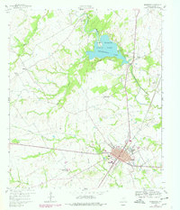
1960 Map of Groesbeck
USGS Topo · Published 1978About this map
Groesbeck serves as the focal point of this Limestone County landscape, centered on the intersection of the Southern Pacific railroad and the Navasota River drainage system. The map documents a significant intersection of local history and recreation at Fort Parker State Park, which encompasses Springfield Lake and several sites of high genealogical value. These include Springfield Cem and the Fort Parker Memorial Cem, alongside the Fort Parker (Historical) site. The rural surroundings are dotted with community landmarks like Round Prairie Sch and Washington High School, while the eastern portion of the quadrangle shows smaller settlements such as Doyle and churches like Canaan Chapel. Industrial activity is noted through Gravel Pits and a series of pipelines traversing the terrain between Frost Creek and Baines Creek.
Find a feature on this map
28 named features on this map. Tap any name to fly to it.
Don’t see what you’re looking for? This feature index may not catch every label — zoom into the map to look around manually.
Map Details
Editions of this 1960 Groesbeck Map
2 editions found
Other maps of this area

1920 · Mexia
USGS Topo · 1:62,500

1954 · Waco
USGS Topo · 1:250,000

1955 · Waco
USGS Topo · 1:250,000

1957 · Groesbeck
USGS Topo · 1:62,500

1960 · Echols
USGS Topo · 1:24,000

1960 · Groesbeck
USGS Topo · 1:24,000

1960 · Tehuacana
USGS Topo · 1:24,000

1963 · Mexia
USGS Topo · 1:24,000

1966 · Thornton
USGS Topo · 1:24,000
1966 · Box Church
USGS Topo · 1:24,000