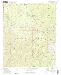
1974 Map of Groom Creek
USGS Topo · Published 1986About this map
The Bradshaw Mountains define this section of the Prescott National Forest, where 1970s mining claims and high-elevation settlements sit among the peaks. The legendary Senator Highway winds through the center of the sheet, connecting the communities of Groom Creek and Potato Patch with historical outposts like Palace Station. This era shows a landscape where active recreation and industrial heritage meet, featuring established youth camps such as Camp Wamatachick and Camp Maripai alongside a high density of lode mines. Prospectors and genealogists can trace the locations of family-held claims and legacy sites like the Jersey Lily Mine, the Davis Dunkirk Mine, and the Venezia site. The terrain is marked by prominent landmarks like Mt Union and Mt Tritle, while the headwaters of the Hassayampa River and Indian Creek drain the rugged interior.
Find a feature on this map
94 named features on this map. Tap any name to fly to it.
Don’t see what you’re looking for? This feature index may not catch every label — zoom into the map to look around manually.
Map Details
Editions of this 1974 Groom Creek Map
2 editions found
Other maps of this area

1887 · Prescott
USGS Topo · 1:250,000

1892 · Prescott
USGS Topo · 1:250,000

1903 · Bradshaw Mountains
USGS Topo · 1:125,000

1903 · Congress
USGS Topo · 1:125,000

1904 · Congress
USGS Topo · 1:125,000

1905 · Jerome
USGS Topo · 1:125,000

1947 · Iron Springs
USGS Topo · 1:62,500

1947 · Mt. Union
USGS Topo · 1:62,500

1947 · Kirkland
USGS Topo · 1:62,500

1947 · Prescott
USGS Topo · 1:62,500