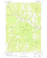
1973 Map of Groton
USGS Topo · Published 1975About this map
Wells River flows through the heart of this Vermont landscape, following a corridor that once supported the region's timber and granite industries. By the early 1970s, the Old Railroad Grade north of Groton serves as a reminder of the rail lines that formerly linked remote settlements like Ricker Mills and West Groton to broader markets. The topography is defined by significant elevations such as Blue Mtn and Pine Mtn, while the Groton State Forest preserves much of the upland terrain.
Find a feature on this map
50 named features on this map. Tap any name to fly to it.
Don’t see what you’re looking for? This feature index may not catch every label — zoom into the map to look around manually.
Map Details
Editions of this 1973 Groton Map
This is the sole edition of this map. No revisions or reprints were ever made.
Other maps of this area

1931 · Woodsville
USGS Topo · 1:48,000

1935 · Woodsville
USGS Topo · 1:62,500

1938 · St. Johnsbury
USGS Topo · 1:48,000

1939 · Plainfield
USGS Topo · 1:48,000

1940 · Plainfield
USGS Topo · 1:62,500

1941 · Woodsville
USGS Topo · 1:62,500

1943 · Plainfield
USGS Topo · 1:62,500

1943 · St. Johnsbury
USGS Topo · 1:62,500

1947 · Corinth
USGS Topo · 1:62,500

1948 · East Barre
USGS Topo · 1:62,500