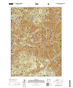
2020 Map of Groundhog Mountain
USGS Topo · Published 2020About this map
Willamette National Forest encompasses this high-elevation landscape in Lane County, dominated by a series of prominent peaks and complex drainage networks. Groundhog Mtn and its neighbor Little Groundhog Mtn stand at the center of the quadrangle, surrounded by other significant heights like Buck Mtn, Moss Mtn, and the appropriately named Logger Butte. The hydrology of the area is defined by the headwaters of numerous creeks, including the Middle Fork, Swift Cr, and Simpson Cr. The presence of Waterdog Lake and the open space of Joes Prairie provide unique ecological markers amidst the dense contour lines of the Cascades. This mapping shows a managed wilderness where forest roads navigate between Juniper Ridge and the various forks of Groundhog Cr, illustrating the modern topographic state of Oregon's timberlands.
Find a feature on this map
54 named features on this map. Tap any name to fly to it.
Don’t see what you’re looking for? This feature index may not catch every label — zoom into the map to look around manually.
Map Details
Editions of this 2020 Groundhog Mountain Map
This is the sole edition of this map. No revisions or reprints were ever made.
Other maps of this area

1917 · Diamond Lake
USGS Topo · 1:125,000

1925 · Waldo Lake
USGS Topo · 1:125,000

1956 · Toketee Falls
USGS Topo · 1:62,500

1956 · Waldo Lake
USGS Topo · 1:62,500

1956 · Summit Lake
USGS Topo · 1:62,500

1956 · Oakridge
USGS Topo · 1:62,500

1958 · Roseburg
USGS Topo · 1:250,000

1959 · Roseburg
USGS Topo · 1:250,000

1978 · Diamond Lake
USGS Topo · 1:100,000

1983 · Oakridge
USGS Topo · 1:100,000