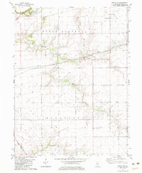
1982 Map of Grove City
USGS Topo · Published 1983About this map
Buckhart Creek and the Baltimore and Ohio railroad corridor define the agricultural and industrial character of this central Illinois landscape. The 1982 map shows a region shaped by energy extraction, featuring the Roby East Oil Field in the northwest and the Consolidated Oil Field to the northeast. Small rural settlements like Bolivia and Grove City anchor the community, while numerous individual oil wells and pipelines cut across the traditional section lines of Mount Auburn and Buckhart townships. Genealogy researchers will find significant landmarks for family history, including the Buckhart Cem, Hinckle Cem, and Bethel Ch. The terrain is generally level prairie punctuated by the notable Sand Ridge and the winding course of local waterways, reflecting a late-twentieth-century balance between commercial drilling and long-standing farming operations.
Find a feature on this map
21 named features on this map. Tap any name to fly to it.
Don’t see what you’re looking for? This feature index may not catch every label — zoom into the map to look around manually.
Map Details
Editions of this 1982 Grove City Map
This is the sole edition of this map. No revisions or reprints were ever made.
Other maps of this area

1923 · Taylorville
USGS Topo · 1:62,500

1925 · Taylorville
USGS Topo · 1:62,500

1952 · Assumption
USGS Topo · 1:62,500

1954 · Niantic
USGS Topo · 1:62,500

1954 · Mechanicsburg
USGS Topo · 1:62,500

1958 · Decatur
USGS Topo · 1:250,000

1961 · Decatur
USGS Topo · 1:250,000

1974 · Willeys
USGS Topo · 1:24,000
1982 · Mechanicsburg
USGS Topo · 1:24,000
1982 · Stonington
USGS Topo · 1:24,000