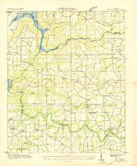
1936 Map of Grove Oak
USGS Topo · Published 1936About this map
Guntersville Reservoir and its proposed extent dominate the northwest corner of this 1936 survey, prepared by the Tennessee Valley Authority as the regional landscape was being reshaped by dam projects. The map documents a dense network of rural infrastructure just before major modernization, centered on the settlement of Grove Oak. A high concentration of community centers is evident through labels for the Prospect Ch, Blackoak Ch, and New Harmony Ch, alongside numerous local schools like Piney Sch and Salem Sch. The terrain is defined by dramatic geography such as The Narrows and several named points including Bethune Point and Red Bud Point. To the south, Town Creek winds toward High Falls Bridge, while the northeastern corner shows the convergence of Middle Sauty Creek and Little Sauty Creek at the county line.
Find a feature on this map
49 named features on this map. Tap any name to fly to it.
Don’t see what you’re looking for? This feature index may not catch every label — zoom into the map to look around manually.
Map Details
Editions of this 1936 Grove Oak Map
This is the sole edition of this map. No revisions or reprints were ever made.
Other maps of this area

1885 · Gadsden
USGS Topo · 1:125,000

1886 · Stevenson
USGS Topo · 1:125,000

1888 · Gadsden
USGS Topo · 1:125,000

1888 · Scottsboro
USGS Topo · 1:125,000

1892 · Scottsboro
USGS Topo · 1:125,000

1892 · Stevenson
USGS Topo · 1:125,000

1892 · Gadsden
USGS Topo · 1:125,000

1893 · Fort Payne
USGS Topo · 1:125,000

1895 · Stevenson
USGS Topo · 1:125,000

1895 · Gadsden
USGS Topo · 1:125,000