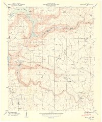
1949 Map of Grove Oak
USGS Topo · Published 1949About this map
Sand Mountain dominates this 1949 topographic study, where the plateau landscape meets the fingers of the newly formed Guntersville Reservoir. The map illustrates a rural Alabama community defined by its proximity to the Tennessee Valley Authority’s hydrological changes, with the Guntersville Reservation Boundary winding along the rugged slopes of South Sauty Creek and Morgan Cove. The upland terrain is dotted with small agricultural settlements and a high density of country churches, including Piney Grove Ch, Prospect Ch, and Mt Nebo Ch, reflecting the social centerpieces of the era.
Find a feature on this map
58 named features on this map. Tap any name to fly to it.
Don’t see what you’re looking for? This feature index may not catch every label — zoom into the map to look around manually.
Map Details
Editions of this 1949 Grove Oak Map
2 editions found
Other maps of this area

1885 · Gadsden
USGS Topo · 1:125,000

1886 · Stevenson
USGS Topo · 1:125,000

1888 · Gadsden
USGS Topo · 1:125,000

1888 · Scottsboro
USGS Topo · 1:125,000

1892 · Scottsboro
USGS Topo · 1:125,000

1892 · Stevenson
USGS Topo · 1:125,000

1892 · Gadsden
USGS Topo · 1:125,000

1893 · Fort Payne
USGS Topo · 1:125,000

1895 · Stevenson
USGS Topo · 1:125,000

1895 · Gadsden
USGS Topo · 1:125,000