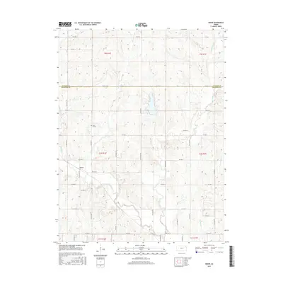
2015 Map of Grove
USGS Topo · Published 2015About this map
Grove sits at the heart of this landscape, positioned along the border between Jackson and Shawnee counties. The terrain is defined by a dense network of watercourses, including the southward-flowing Soldier Cr and its tributaries such as Little Soldier Cr and Messhoss Cr. The map reveals a strictly regulated rural grid system, with roads like NW 66th St and NW 94th St dividing the land into clear sections. Local history is anchored by the Walnut Hill Cem, located near the banks of Walnut Cr. The drainage patterns of Dutch Cr and other small streams highlight the natural topography that shaped the placement of farmsteads and rural infrastructure in this part of Kansas.
Find a feature on this map
28 named features on this map. Tap any name to fly to it.
Don’t see what you’re looking for? This feature index may not catch every label — zoom into the map to look around manually.
Map Details
Editions of this 2015 Grove Map
This is the sole edition of this map. No revisions or reprints were ever made.
Other maps of this area

1889 · Topeka
USGS Topo · 1:125,000

1894 · Topeka
USGS Topo · 1:125,000

1950 · Kansas City
USGS Topo · 1:250,000

1950 · Topeka
USGS Topo · 1:24,000

1951 · Topeka
USGS Topo · 1:24,000

1952 · Rossville
USGS Topo · 1:24,000

1952 · Silver Lake
USGS Topo · 1:24,000

1952 · Elmont
USGS Topo · 1:24,000

1952 · Grove
USGS Topo · 1:24,000
1952 · Willard
USGS Topo · 1:24,000