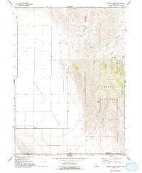
1968 Map of Grover Canyon
USGS Topo · Published 1993About this map
Samaria Mountains dominate the eastern half of this 1960s landscape, their steep slopes carved by a network of drainage systems including Grover Canyon, Buckboard Canyon, and Elevator Canyon. To the west, the topography opens into the broad, flat expanse of the Pocatello Valley, where the small settlement of Ridgedale sits near the state line. The survey captures a high-desert environment defined by its water sources, marking several critical locations such as Grover Spring, Dry Pine Spring, and D H Spring. These springs and the intermittent flow of Samaria Creek were vital for the ranching operations indicated by the numerous fence lines across the valley floor. The boundary between Oneida Co, Idaho, and Box Elder Co, Utah, runs across the southern portion of the sheet, highlighting the remote borderland character of the region during this era.
Find a feature on this map
19 named features on this map. Tap any name to fly to it.
Don’t see what you’re looking for? This feature index may not catch every label — zoom into the map to look around manually.
Map Details
Editions of this 1968 Grover Canyon Map
2 editions found
Other maps of this area

1954 · Pocatello
USGS Topo · 1:250,000

1954 · Brigham City
USGS Topo · 1:250,000

1958 · Pocatello
USGS Topo · 1:250,000

1958 · Brigham City
USGS Topo · 1:250,000

1962 · Brigham City
USGS Topo · 1:250,000

1968 · Ireland Springs
USGS Topo · 1:24,000

1968 · Grover Canyon
USGS Topo · 1:24,000

1968 · Samaria
USGS Topo · 1:24,000

1968 · Malad City West
USGS Topo · 1:24,000
1968 · Limekiln Knoll
USGS Topo · 1:24,000