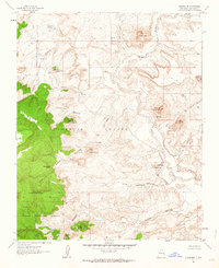
1961 Map of Guadalupe
USGS Topo · Published 1964About this map
The high desert landscape of Sandoval County is defined by the winding course of the Rio Puerco and its confluence with Arroyo Chico. This area, surveyed in the early 1960s, centers on the small settlement of Guadalupe, where the Guadalupe Cem and Ojo del Padre stand as evidence of long-established habitation in this arid terrain. The map captures a transition from the volcanic peaks and mesas like Cerro de Guadalupe and Cerro Cuate to the deep incisions of Cañon Guadalupe and Cañon Salado.
Find a feature on this map
40 named features on this map. Tap any name to fly to it.
Don’t see what you’re looking for? This feature index may not catch every label — zoom into the map to look around manually.
Map Details
Editions of this 1961 Guadalupe Map

Other maps of this area

1883 · Mt. Taylor
USGS Topo · 1:250,000

1886 · Mt. Taylor
USGS Topo · 1:250,000

1892 · Mt. Taylor
USGS Topo · 1:250,000

1899 · Mt. Taylor
USGS Topo · 1:250,000

1958 · Albuquerque
USGS Topo · 1:250,000

1961 · Cerro Parido
USGS Topo · 1:24,000

1961 · Cerro Tinaja
USGS Topo · 1:24,000

1961 · Arroyo Empedrado
USGS Topo · 1:24,000
1961 · Canada Calladita
USGS Topo · 1:24,000
1961 · Laguna Seca
USGS Topo · 1:24,000