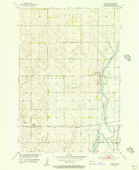
1955 Map of Guelph
USGS Topo · Published 1956About this map
The James River meanders through the eastern portion of this Dickey County landscape, shaping a wide floodplain that includes the James River National Wildlife Refuge and Dakota Lake. The map illustrates a mid-century agricultural region defined by the townships of Clement, Hudson, Port Emma, and Riverdale. Transportation is anchored by two major rail lines: the Great Northern railroad passing through Guelph in the west, and the Chicago and Northwestern serving the community of Ludden in the southeast corner. The terrain is marked by numerous depressions and wetlands characteristic of the drift prairie, with specific local resources noted such as a Flowing Well and several instances of a Gravel Pit. Genealogists may find the Ludden Cem and the precise platting of these small prairie settlements particularly valuable for tracing local history.
Find a feature on this map
15 named features on this map. Tap any name to fly to it.
Don’t see what you’re looking for? This feature index may not catch every label — zoom into the map to look around manually.
Map Details
Editions of this 1955 Guelph Map
This is the sole edition of this map. No revisions or reprints were ever made.
Other maps of this area

1894 · Hecla
USGS Topo · 1:62,500

1894 · Savo
USGS Topo · 1:62,500

1894 · Fullerton
USGS Topo · 1:62,500

1894 · Oakes
USGS Topo · 1:62,500

1895 · Lamoure
USGS Topo · 1:125,000

1896 · Columbia
USGS Topo · 1:125,000

1918 · La Moure
USGS Topo · 1:125,000

1952 · Glover
USGS Topo · 1:24,000

1952 · Oakes
USGS Topo · 1:24,000

1953 · Jamestown
USGS Topo · 1:250,000