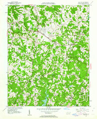
1951 Map of Guilford
USGS Topo · Published 1963About this map
The Greensboro High Point Airport serves as a modern hub at the center of this 1951 landscape, where the growing aviation industry meets an older agricultural world. This transition is evident in the cluster of rural institutions surrounding the airfield, such as Friendship Ch and the neighboring settlement of Friendship. To the east, the historic academic environment of Guilford College stands in contrast to the emerging recreational and memorial spaces like the Sedgefield Country Club and Guilford Memorial Park.
Find a feature on this map
47 named features on this map. Tap any name to fly to it.
Don’t see what you’re looking for? This feature index may not catch every label — zoom into the map to look around manually.
Map Details
Editions of this 1951 Guilford Map
5 editions found
Other maps of this area

1949 · High Point West
USGS Topo · 1:24,000

1950 · High Point East
USGS Topo · 1:24,000

1951 · High Point East
USGS Topo · 1:24,000

1951 · Guilford
USGS Topo · 1:24,000

1951 · Lake Brandt
USGS Topo · 1:24,000

1951 · Greensboro
USGS Topo · 1:24,000

1953 · Raleigh
USGS Topo · 1:250,000

1953 · Charlotte
USGS Topo · 1:250,000

1953 · Winston-Salem
USGS Topo · 1:250,000

1953 · Greensboro
USGS Topo · 1:250,000