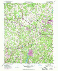
1951 Map of Guilford
USGS Topo · Published 1970About this map
Guilford College serves as a central anchor for this Piedmont landscape during a period of significant regional integration. The map traces the early footprint of the Greensboro High Point Winston-Salem Airport, illustrating how aviation infrastructure began to reshape the rural spaces between these growing North Carolina cities. The drainage of the Deep River, including its East Fork and West Fork, dictates the positioning of established communities like Friendship and Jamestown.
Find a feature on this map
36 named features on this map. Tap any name to fly to it.
Don’t see what you’re looking for? This feature index may not catch every label — zoom into the map to look around manually.
Map Details
Editions of this 1951 Guilford Map
5 editions found
Other maps of this area

1949 · High Point West
USGS Topo · 1:24,000

1950 · High Point East
USGS Topo · 1:24,000

1951 · High Point East
USGS Topo · 1:24,000

1951 · Guilford
USGS Topo · 1:24,000

1951 · Lake Brandt
USGS Topo · 1:24,000

1951 · Greensboro
USGS Topo · 1:24,000

1953 · Raleigh
USGS Topo · 1:250,000

1953 · Charlotte
USGS Topo · 1:250,000

1953 · Winston-Salem
USGS Topo · 1:250,000

1953 · Greensboro
USGS Topo · 1:250,000