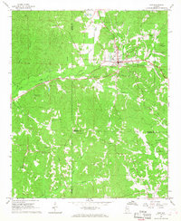
1967 Map of Guin
USGS Topo · Published 1968About this map
The town of Guin serves as the focal point of this 1967 survey, situated at the junction of the St Louis - San Francisco railroad and a network of rural roads traversing the hills of Marion County. The landscape is defined by the headwaters of numerous waterways, including Purgatory Creek and Hughes Creek, which drain the surrounding timberlands. Notable for its high density of rural institutions, the map records several community centers such as New Hope Ch, White Rock Ch, and Mount Olive Ch.
Find a feature on this map
40 named features on this map. Tap any name to fly to it.
Don’t see what you’re looking for? This feature index may not catch every label — zoom into the map to look around manually.
Map Details
Editions of this 1967 Guin Map
This is the sole edition of this map. No revisions or reprints were ever made.
Other maps of this area

1953 · Birmingham
USGS Topo · 1:250,000

1953 · West Point
USGS Topo · 1:250,000

1956 · Birmingham
USGS Topo · 1:250,000

1956 · Gadsden
USGS Topo · 1:250,000

1956 · Tupelo
USGS Topo · 1:250,000

1957 · Birmingham
USGS Topo · 1:250,000

1958 · Tupelo
USGS Topo · 1:250,000

1958 · West Point
USGS Topo · 1:250,000

1958 · Gadsden
USGS Topo · 1:250,000

1960 · Gadsden
USGS Topo · 1:250,000