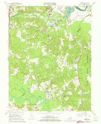
1966 Map of Guinea
USGS Topo · Published 1973About this map
The Jackson Shrine stands as a significant historical marker near the settlement of Guinea, a community defined by its position along the Richmond Fredericksburg and Potomac railroad. This region south of Fredericksburg is a landscape of rural junctions and spiritual centers, where numerous congregations such as Forest Hill Ch, Second New Hope Ch, and Macedonia Ch serve local families. The map illustrates a transitional period in the 1960s and 70s, as traditional landmarks like Hamilton Crossing and Massaponax persist alongside modern infrastructure. To the east, the A. P. Hill military reservation and the winding Rappahannock River form natural and jurisdictional boundaries, while smaller waterways like the Po River and Poni River drain the wooded interior. Industrial activity is evident in the numerous Gravel Pits scattered near New Post, highlighting the area's geological utility.
Find a feature on this map
43 named features on this map. Tap any name to fly to it.
Don’t see what you’re looking for? This feature index may not catch every label — zoom into the map to look around manually.
Map Details
Editions of this 1966 Guinea Map
4 editions found
Other maps of this area

1887 · Spottsylvania
USGS Topo · 1:125,000

1889 · Fredericksburg
USGS Topo · 1:125,000

1892 · Fredericksburg
USGS Topo · 1:125,000

1892 · Spottsylvania
USGS Topo · 1:125,000

1894 · Fredericksburg
USGS Topo · 1:125,000

1926 · Stafford
USGS Topo · 1:62,500

1931 · Stafford
USGS Topo · 1:62,500

1942 · Bowling Green
USGS Topo · 1:31,680

1942 · Woodford
USGS Topo · 1:31,680

1942 · Guinea
USGS Topo · 1:31,680