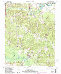
1966 Map of Guinea
USGS Topo · Published 2000About this map
The Jackson Shrine stands as a focal point near Guinea, marking a site of deep historical significance within the landscape of Spotsylvania and Caroline Counties. This mid-century survey reveals a transition from the preserved grounds of the Fredericksburg Spotsylvania Nat Mil Park to the expansive military territory of the A P Hill Military Reservation. The terrain is defined by the convergence of several waterways, including the Rappahannock River and the branching systems of the Poni River, Po River, and Ni River.
Find a feature on this map
45 named features on this map. Tap any name to fly to it.
Don’t see what you’re looking for? This feature index may not catch every label — zoom into the map to look around manually.
Map Details
Editions of this 1966 Guinea Map
4 editions found
Other maps of this area

1887 · Spottsylvania
USGS Topo · 1:125,000

1889 · Fredericksburg
USGS Topo · 1:125,000

1892 · Fredericksburg
USGS Topo · 1:125,000

1892 · Spottsylvania
USGS Topo · 1:125,000

1894 · Fredericksburg
USGS Topo · 1:125,000

1926 · Stafford
USGS Topo · 1:62,500

1931 · Stafford
USGS Topo · 1:62,500

1942 · Bowling Green
USGS Topo · 1:31,680

1942 · Woodford
USGS Topo · 1:31,680

1942 · Guinea
USGS Topo · 1:31,680