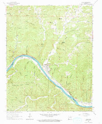
1964 Map of Guion
USGS Topo · Published 1965About this map
The White River carves a deep valley through the limestone bluffs of the Ozarks, serving as the central artery for the river-and-rail economy of Guion. This 1964 survey captures the township during a period of industrial activity, characterized by numerous quarries and gravel pits along the riverbanks. The Missouri Pacific railroad traces the northern bank, connecting the riverside settlement and its industrial sites to wider markets.
Find a feature on this map
60 named features on this map. Tap any name to fly to it.
Don’t see what you’re looking for? This feature index may not catch every label — zoom into the map to look around manually.
Map Details
Editions of this 1964 Guion Map
This is the sole edition of this map. No revisions or reprints were ever made.
Other maps of this area

1890 · Batesville
USGS Topo · 1:125,000

1890 · Mountain Home
USGS Topo · 1:125,000

1891 · Mountain Home
USGS Topo · 1:125,000

1891 · Batesville
USGS Topo · 1:125,000

1892 · Mountain View
USGS Topo · 1:125,000

1894 · Mountain View
USGS Topo · 1:125,000

1894 · Mountain Home
USGS Topo · 1:125,000

1942 · Bethesda
USGS Topo · 1:24,000

1942 · Mt Pleasant
USGS Topo · 1:31,680

1945 · Harrison
USGS Topo · 1:250,000